There are many industries that benefit from drain mapping. Typically, mapping is well–suited for councils and highway authorities, construction companies, and those in manufacturing. Mapping can also be useful for domestic pipes and commercial outlets. If there is a need to fully understand how a drainage system sits beneath the surface of the ground, then drain mapping can be an incredibly useful tool.
Customer reviews on Google
4.3 ratings of 38 reviews

John Newell

4 weeks ago

Lindsay Jones
a month ago

Tia-Leoni Wright
2 months ago

Bert Felix
3 months ago
Our Expert Drain Mapping Service
At Metro Rod, we specialise in drainage maps and drainage layout plans. Our highly trained engineers provide accurate drain mapping surveys and expert advice on the condition of your drains for domestic, commercial, construction, highways, manufacturing, and property development sectors.
We understand the importance of precise drain mapping, which is why our service is tailored to your needs. Find your local Metro Rod drain mapping specialist near you or call 0800 66 88 00 for a free site visit and no-obligation quote.
What is Drain Mapping?
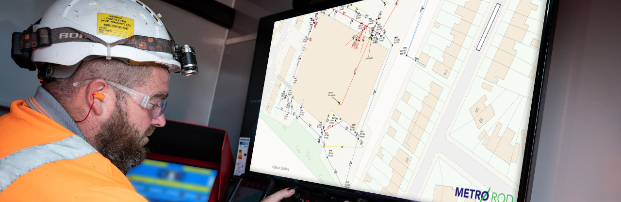
Drain mapping, also known as asset mapping, uses advanced GPS technology to create a bespoke map of drains, including pipes, manholes, and gullies. A drainage mapping survey also identifies pipe size, depth, directional flow, and foul water drains, giving you a complete overview of your drainage system.
Watch our video to learn more:
Why Consider Drainage Mapping?
A drain map is a valuable planning and site management tool across a variety of industries, having a wide range of benefits:
- Supports pollution prevention and flood risk management, enabling fast emergency response to spills, fires, or other incidents.
- Ensures compliance for regulated sites such as COMAH (Control of Major Accident Hazards) and EPR (Environmental Permitting Regulations) by providing accurate, legally compliant drain maps.
- Required before building projects to avoid costly damage to existing drainage systems.
How Does Drain Mapping Work?
At Metro Rod, we use cutting-edge GPS technology with 2cm accuracy and OSGM15 coordinates to deliver precise drain mapping surveys. After collecting data, we produce a tailored report quickly to meet your exact specifications. Our engineers work efficiently on-site with minimal disruption, ensuring accurate results and exceptional customer service.
Further Reading on Drain Mapping:
-
What Does the Drain Mapping Report Include?
Drain mapping results in an in-depth drainage layout plan, which can be tailored to your requirements. The report includes four key elements, including:
- A site map with a schematic drawing of the drainage system
- An asset register detailing the location, size, access points, and use of each drain section
- Manhole record cards showing images of each access point
- An interactive Google Maps overlay. Allowing you to click on each drain section and see the corresponding granular details and photos.
We can provide a DXF file compatible with your CAD system, including OS tile backgrounds if needed. Additionally, we offer bespoke data collection to map external features such as streetlights, park benches, and more to meet your specific requirements.
Contact Us
Accredited By


Drain Mapping FAQs
What industries is drain mapping useful for?
What is included in a drain mapping report?
At Metro Rod, we deliver a comprehensive drain mapping report, including pipe details, manhole and gully locations, and water flow direction. You’ll also receive a detailed schematic drawing, an asset register, manhole record cards with images, and a Google Maps overlay for interactive site exploration.
How long does drain or asset mapping take?
How long drain mapping can take depends on the size of the site that needs to be mapped. Smaller sites take less time than larger sites. We understand the importance of minimising any disruption to your business and will work with you to provide the service at a time that suits you. If you’d like to know how long drain or asset mapping would take on your site, please contact your local Metro Rod drain mapping specialist or call us on 0800 66 88 00.
What special software is used in drain mapping?
To conduct a drainage map, we use a series of specialist software designed to give you the most accurate drainage map possible. This specialist software includes a Global Navigation Satellite System (known as a GNSS) that is accurate up to 2cm. Our engineers also track coordinates using OSGM15.
How much does drain mapping cost?
The cost of drain mapping can vary depending on a few factors, including the size of the drainage area that needs to be mapped. Contact your local drainage engineer or call us today on 0800 66 88 00 for a no-obligation free quote.
How do I find drainage plans for my house?
To find drainage plans for your house, start by checking property documents or building plans, as they often include this information. If unavailable, contact your local water authority or council for records. Alternatively, a professional drain mapping service like Metro Rod can create an accurate, up-to-date plan using GPS technology, ensuring you know the location, depth, and flow of your drainage system.
Customer Reviews
Here's what our customers say about us
Messaged Metro Rod in Dartford for a price to unblock my drain and had a call early Read more
They come out pretty fast . Tom was brilliant bery hard working very respectful took his shoes Read more
We had two engineers- Jared & Zacc (I believe there names were) come out to our property Read more
3,629 trees planted
For every review, we’ll plant a tree
Each and every written review for Metro Rod plants a new tree. ReviewForest captures every review and guarantees the tree is planted.
Trusted by: